Djargurd Wurrung
The Djargurd Wurrung are the people of the plains, lakes and stony rises, grasslands and woodlands country that is east of Mount Emu Creek and west of Lake Corangamite, extending to Mt Elephant and Cressy in the North, and to Cobden and Swan Marsh in the South.
Wombeetch puyuun - alias Camperdown George
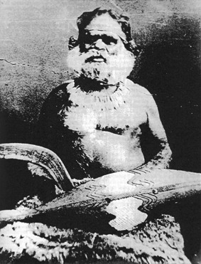
Wombeetch puyuun (Camperdown George)
was born during the period when the
lands of the Djargurd Wurrung were
being taken by settlers. During his life
his people suffered terrible losses.
His grave in Camperdown Cemetery is
marked by a stone obelisk erected in
his honour by James Dawson.
was born during the period when the
lands of the Djargurd Wurrung were
being taken by settlers. During his life
his people suffered terrible losses.
His grave in Camperdown Cemetery is
marked by a stone obelisk erected in
his honour by James Dawson.
Alternative names and name spellings
Dantgurt Wurrung
Language
The Djargurd Wurrung language is closely related to Girai Wurrung and Dhauwurd Wurrung, having 80% to 90% vocabulary in common with them.
Relationships with other language-culture groups
The Djargurd Wurrung intermarried with the Gulidjan and possibly with clans of the Djab Wurrung and Girai Wurrung, with whom they shared their moieties. They also intermarried with the Wada Wurrung in spite of having a different descent system.
Beliefs and laws
It is probable that clans were organised into two moieties. As with the Girai Wurrung, these would have been the Gabadj (Black Cockatoo) and the Guragidj (White Cockatoo). Each clan would have belonged to one or other of these, and marriages would have been arranged so that partners were from different moieties. Among the people of this region of Victoria, moieties were inherited matrilineally (i.e. from the mother).
The lands of the Djargurd Wurrung
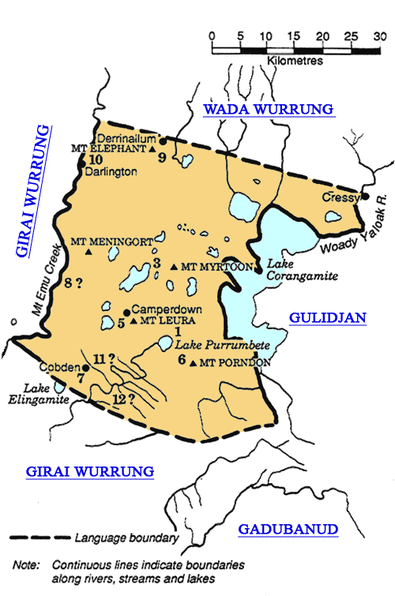
The numbers on this map indicate the approximate locations of clan estates. The entire landscape was a mosaic of such estates. Through intermarriage and other alliances people were able to access land and resources far beyond their own estates. Access to land and resources was negotiated through discussion, marriage, ceremony and adherence to law.
It is possible that there were more clans than listed here.
This map is derived from Clark (1990)
Clans
No. Clan name Approximate location
1. Barumbidj gundidj Lake Purumbete
2. Djargurd balug Unknown
3. Koenghegulluc Lake Colongulac and east of Mt Myrtoon
4. Korrungow werroke gundidj Unknown
5. Leehoorah gundidj Mt Leura and lakes Bullen-Merri & Gnotuk
6. Mullungkil gundidj South of Lake Purumbete, including Mt Porndon
7. Netcunde Cobrico Swamp
8. Tarnbeere gundidj Eastern bank of Mt Emu Creek
9. Teerinyillum gundidj Mt Elephant
10. Uropine gundidj Darlington
11. Wane gundidj colac Near Lake Elingamite
12. Worong gundidj East of Lake Elingamite
Bibliography
Clark (1990)
Aboriginal Languages and Clans: An historical atlas of western and central Victoria.
All the above information courtesy of the Corangamite CMA indiginous information & hertiage website.
